The Post-Apocalyptic Roadmap/Texas: Difference between revisions
1d4chan>RockMongler No edit summary |
1d4chan>RockMongler No edit summary |
||
| Line 11: | Line 11: | ||
tl;dr: Since the rest of Texas is nuked/unlivable, survivors from the large metro areas have moved into deep east TX and have formed a somewhat autonomous region of farmers, lumberjacks, and oil producers. | tl;dr: Since the rest of Texas is nuked/unlivable, survivors from the large metro areas have moved into deep east TX and have formed a somewhat autonomous region of farmers, lumberjacks, and oil producers. | ||
==Images== | |||
<gallery> | |||
Image:EastTXlake.jpg|A lake showing the terrain of East Texas | |||
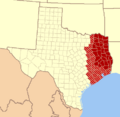
Image:EastTexasMap.png| Map of East Texas (southern dark red areas being most of what is discussed) | |||
</gallery> | |||
===Links=== | |||
[[The Post-Apocalyptic Roadmap]] | [[The Post-Apocalyptic Roadmap]] | ||
Revision as of 14:32, 6 October 2008
East Texas
Being that Dallas/Fort Worth is a dilapidated wasteland due to lack of fresh water and Houston a large field of glass, as are the several of the large military bases in central Texas and the Army supply base near Texarkana, and much more west of Central Texas, and you already have a near uninhabitable wasteland. Because of this, and other factors to be named, East Texas would probably become the seat of power of the New Republic of Texas.
East Texas is a large rural area with good soil, plenty of surface water, and even more groundwater. Before the accident, it was filled with chicken farms, oil wells, logging operations, and small farming operations. Luckily, after the larger cities in TX were hit, along with New Orleans (shipping and oil processing) and the prevailing winds blowing to the west, there was not too much fallout dropped the central portion of east TX.
Almost all of the above ground water sources are tainted, but due to the large number of aquifer layers through the region, there is plenty of fresh, potable water. The cities that have taken a power hold in the region are Nacogdoches and Lufkin, due to their large populations before the accident. Since the event, a lot of people have moved into the safer region from the outskirts of Houston, Dallas, and Austin.
Many of the people who moved in have filled in the region along US 59 between Nacogdoches and Lufkin, forming a large ghetto of somewhat poorly constructed houses connecting the two cities. Away from the heavily populated areas is huge amounts of land, perfect for farming enough food to support the population of the region. Beyond the availability of enough food to support the populace, there is lots of black gold still being pumped out of the ground which makes for a populace able to move further away from the populated areas to farm. Small refineries have been constructed, and are currently being expanded to allow for more even more readily available petroleum products.
There is also still electricity available to much of the region due to the large amounts of coal easily available near the surface.
tl;dr: Since the rest of Texas is nuked/unlivable, survivors from the large metro areas have moved into deep east TX and have formed a somewhat autonomous region of farmers, lumberjacks, and oil producers.
Images
-
A lake showing the terrain of East Texas
-
Map of East Texas (southern dark red areas being most of what is discussed)

